
The National Meteorological Service highlights the effects of the cold front 12 and two low-pressure channels in the Mexican territory
Mexico.- The National Meteorological Service published the weather forecast extended to 24 hours that will prevail this Friday, November 13, 2020.
In its report, it indicates that front No. 12 will extend over the eastern Gulf of Mexico, without affecting the Mexican Republic, in addition to a low-pressure channel, over the southeast of the country, will increase the probability of heavy occasional rains in areas from Oaxaca, Chiapas, Tabasco, Campeche, and Quintana Roo.
The National Meteorological Office anticipates that another low-pressure channel, on the north of Mexico, will interact with a front located in the south of the United States, causing isolated rains and wind with gusts of 50 to 60 km / h in Coahuila, Nuevo León, and Tamaulipas. In the rest of the National Territory, low rain potential will prevail, in addition to a cold environment with possible frosts at dawn in mountainous areas of the north and center.

Precipitation forecast for today, November 13, 2020:
• Intervals of showers with heavy point rains (25 to 50 mm): Oaxaca, Chiapas, Tabasco, Campeche and Quintana Roo.
• Intervals of showers (5.1 to 25 mm): Guerrero, Veracruz and Yucatán.
• Isolated rains (0.1 to 5 mm): Coahuila, Nuevo León, Tamaulipas, Jalisco, Michoacán and Puebla.
Forecast of minimum temperatures for today, November 13, 2020:
• Minimum temperatures of -5 to 0 ° C with frosts: mountainous areas of Chihuahua and Durango.
• Minimum temperatures of 0 to 5 ° C and possible frosts: mountainous areas of Baja California, Sonora, Zacatecas, State of Mexico, Tlaxcala and Puebla.
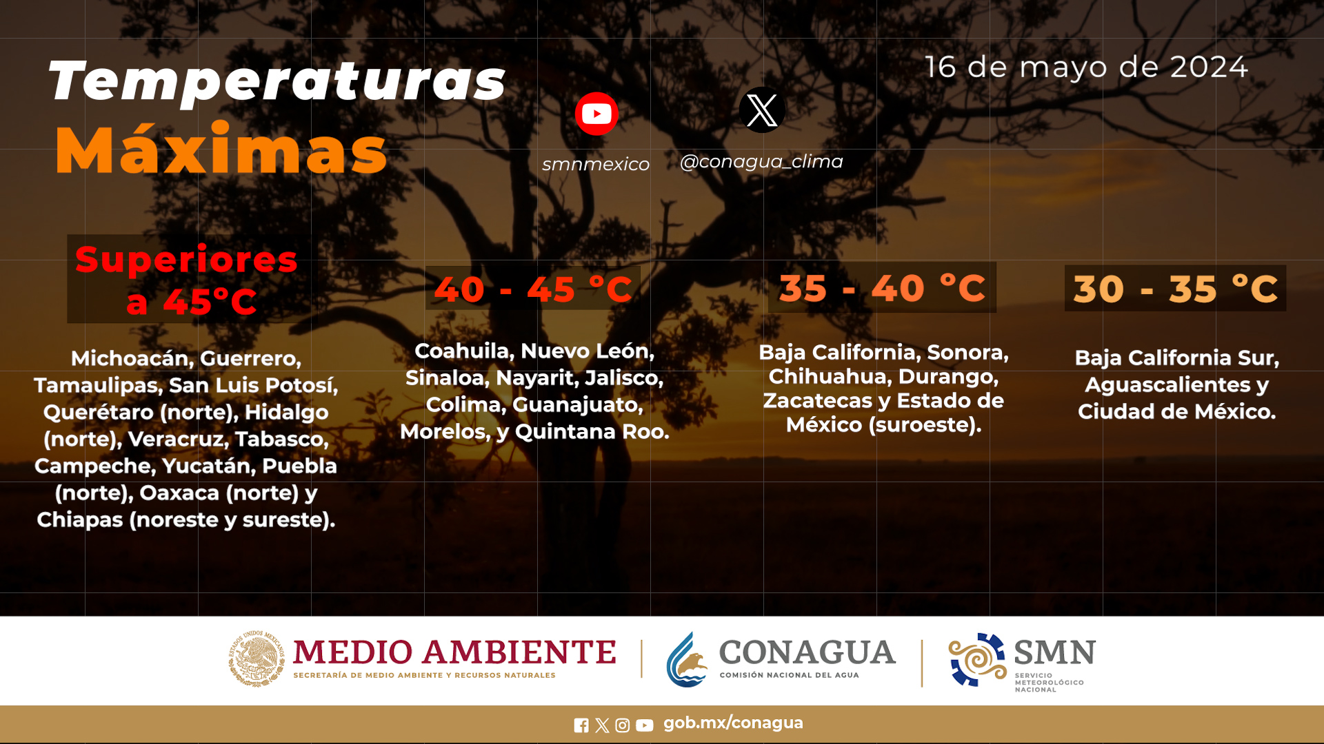
Forecast of maximum temperatures for today, November 13, 2020:
• Maximum temperatures of 35 to 40 ° C: Michoacán and Guerrero.
Wind forecast for today, November 13, 2020:
• Wind with gusts of 50 to 60 km / h: Coahuila, Nuevo León, Tamaulipas, Oaxaca (east) and Gulf of Tehuantepec.
Forecast by regions:
Valley of Mexico: Clear skies most of the day and no rain in the region. A cold environment with possible frosts at dawn in mountainous areas of the State of Mexico. East and northeast wind from 10 to 25 km / h with gusts of 40 km / h in the State of Mexico. In Mexico City, a maximum temperature of 25 to 27 ° C and a minimum of 10 to 12 ° C is forecast. For the capital of the State of Mexico, a maximum temperature of 24 to 26 ° C and a minimum of 4 to 6 ° C.
Baja California Peninsula: Clear skies most of the day and no rain in the region. A very cold environment during the morning with frosts in mountainous areas of Baja California and temperate in the afternoon. Northwest wind between 25 and 40 km / h.
North Pacific: Clear skies and no rain in the region. The cold environment in the morning with frosts in the mountainous areas of Sonora and temperate atmosphere in the afternoon. West wind between 15 and 25 km / h.
Central Pacific: Partly cloudy sky in the afternoon with the probability of isolated rains in Jalisco and Michoacán. Hot environment and west component wind from 10 to 25 km / h.
South Pacific: Cloudy sky in the afternoon with punctual heavy rains in Chiapas and Oaxaca, as well as intervals of showers in Guerrero. The hot environment in coastal areas. North component wind with gusts of 50 to 60 km / h in eastern Oaxaca and the Gulf of Tehuantepec.
Gulf of Mexico: Cloudy sky during the afternoon with heavy occasional rains in Tabasco, intervals of showers in Veracruz, as well as isolated rains in Tamaulipas. Cold in the morning and warm in the afternoon. East and northeast wind from 15 to 30 km / h with gusts of 50 to 60 km / h in Tamaulipas.
Yucatán Peninsula: Cloudy sky in the afternoon with heavy occasional rains in Campeche and Quintana Roo, as well as intervals of showers in Yucatán. Warm environment. Northwest wind between 15 and 30 km / h.
Mesa del Norte: Partly cloudy sky in the afternoon with the probability of isolated rains in the north of Coahuila, Nuevo León, and Tamaulipas. A very cold environment with frosts in mountain areas at dawn and a warm atmosphere in the afternoon. Variable direction wind with gusts of 50 to 60 km / h in Coahuila and Nuevo León.
Central Table: Clear to cloudy skies with isolated rains in Puebla. A cold environment with possible morning frosts in mountainous areas. East and northeast wind from 15 to 30 km / h.
The maximum rains of the last 24 hours (in millimeters) were registered in:
Campeche, Camp., 10.4; Tizimín, Yuc., 9.4; José María Morelos, Q. Roo, 3.2; Ávila Camacho, Pue., 2.0 and Obs. Veracruz, Ver., 1.3.
The maximum temperatures (in ° C) were recorded in:
Arriaga, Chis., 37.2; Salina Cruz, Oax., 36.2; Soto La Marina, Tamps. and Acapulco, Gro., 34.2; Valladolid, Yuc. and Colima, Col., 33.5; Zamora, Mich., 33.2 and Mexico City International Airport, 26.0.
The minimum temperatures (in ° C) were registered in:
Cumbres de Majalca, Chih., -4.7; Las Vegas, Dgo., -2.3; Amanalco, Edo. of Mex., -0.6; Huamantla, Tlax., 0.4; La Florida, Zac., 0.7; La Rumorosa, BC, 0.9; Perote, Ver., 1.3; Yecora, Son. and Apan, Hgo., 1.4; Lagunas de Zempoala, Mor., 2.8 and Mexico City International Airport, 11.0.
Source: smn.conagua.gob.mx


